Off leash dog park study published; Lincoln Park and West Seattle Stadium considered for expansion
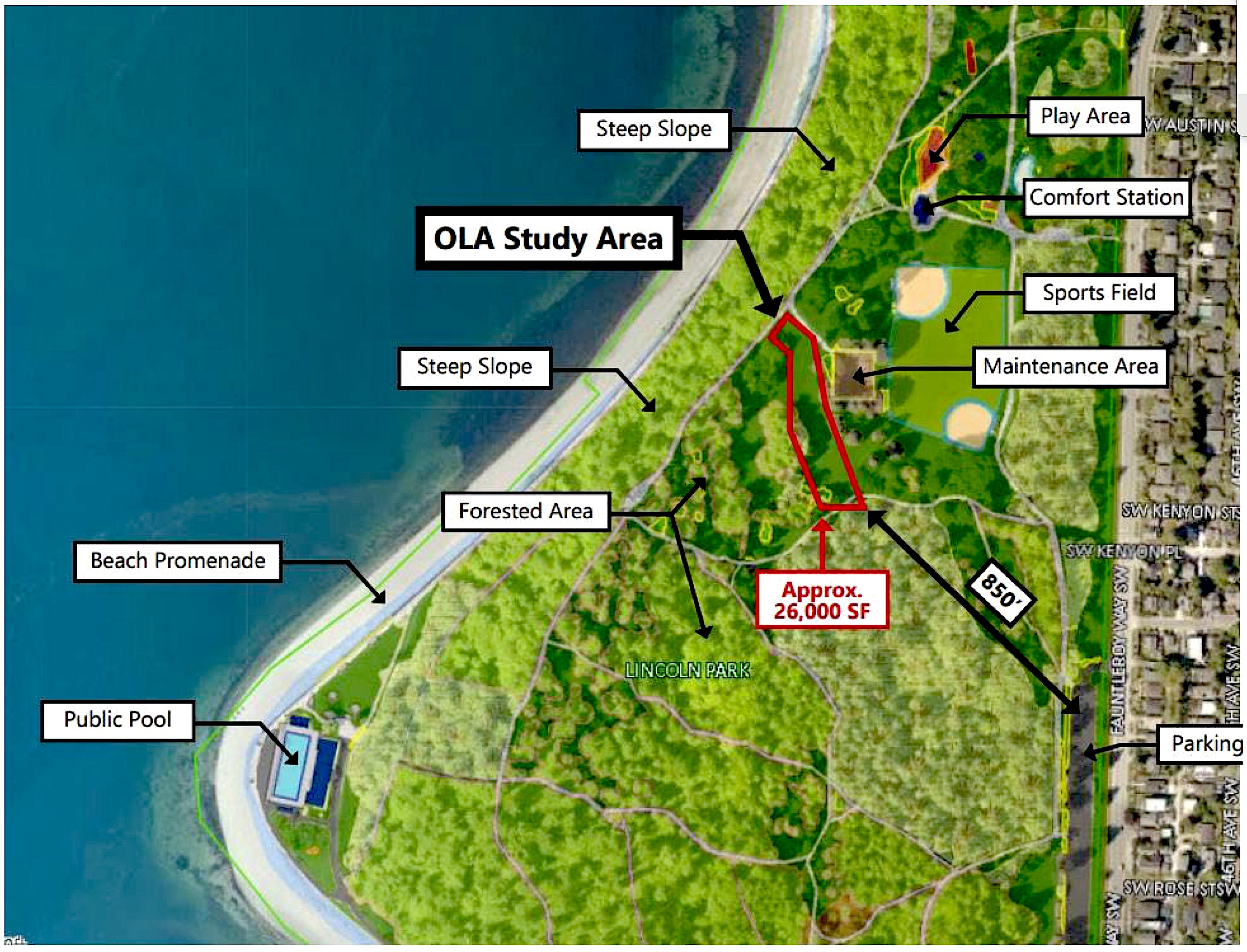
The Off Leash area being studied in Lincoln Park is in the north central area and is approximately 26,000 square feet in size.
Seattle Parks and Recreation illustration
Wed, 06/14/2023
Seattle Parks and Recreation has been studying an expansion of off-leash dog parks in the city and published the results of their study on June, 12. Two sites in West Seattle are under consideration. Lincoln Park and West Seattle Stadium.
SEE THE FULL STUDY HERE
The Lincoln Park site would be approximately 26,000 square feet in size and occupy a space in the north central section of the park adjacent to a maintenance shed, and across from the north ball field.
The West Seattle Stadium site would be in between Totem Pole Park on 35th SW and the West Seattle Golf Course.
OLA Expansion Study Executve Summary
The 2023 Off-Leash Area (OLA) Expansion Study is a review of 32 Seattle Parks and Recreation (SPR) owned sites to determine their feasibility for possible OLA development. While demand for dog OLA facilities in Seattle has grown since the pilot program was launched in 1997, identifying sites has presented a unique challenge in a growing city. The new SPR Metropolitan Park District budget includes funding for the construction of two new OLAs in Seattle beginning in 2025, and funding for the design of a third. Part of this budget directive included the stipulation that one of these new areas will be located in West Seattle and the other somewhere else in Seatle. A decision has not yet been made on where the third site to be designed should be located.
Official SPR OLA siting criteria were adopted with the 1997 resolution and the 2017 People, Dogs, and Parks Plan and guided the technical review of each site included here. These criteria were developed to protect existing parkland and uses while creating safe and enjoyable space for people to exercise their dogs.
These criteria are:
-
The site must not conflict with existing park uses in a way that creates safety issues.
-
The site must not be located in a park that is a designated Seattle landmark or be listed on the
State or Federal register of historic places.
-
The site must not be located in natural areas under active restoration, or in an environmentally
critical area (ECA).
-
SPR must have preliminary approval from the site owner, if not on SPR owned land.
Other Considerations:
-
The site should address existing geographic need of OLA facilities.
-
The site must be Accessible, or a plan must be created to make it accessible.
-
The site must not have significant vegetation and large trees.
-
The proposed site must be at least 50 feet away from other property lines.
-
Flat sites are preferred to slopes, because surfacing erodes over time on slopes.
-
SPR must consider access to parking spots or accessibility by public transportation.
This study includes a review of 32 sites around the city including every council district. These sites have been reviewed by SPR subject mater experts from landscape architecture, grounds maintenance, environmental analysis, plant ecology, arboriculture, and more to verify their suitability for OLA use against the criteria listed above. After this internal review nine sites were recommended as being technically feasible for OLA development and are ready to move to the next step to discuss with community members from all over Seatle. This step will be critical to get a better understanding of how these spaces are currently being used and how adding an OLA there could impact the space. The feasibility review of these nine sites is included below to provide insight into the previous review process.

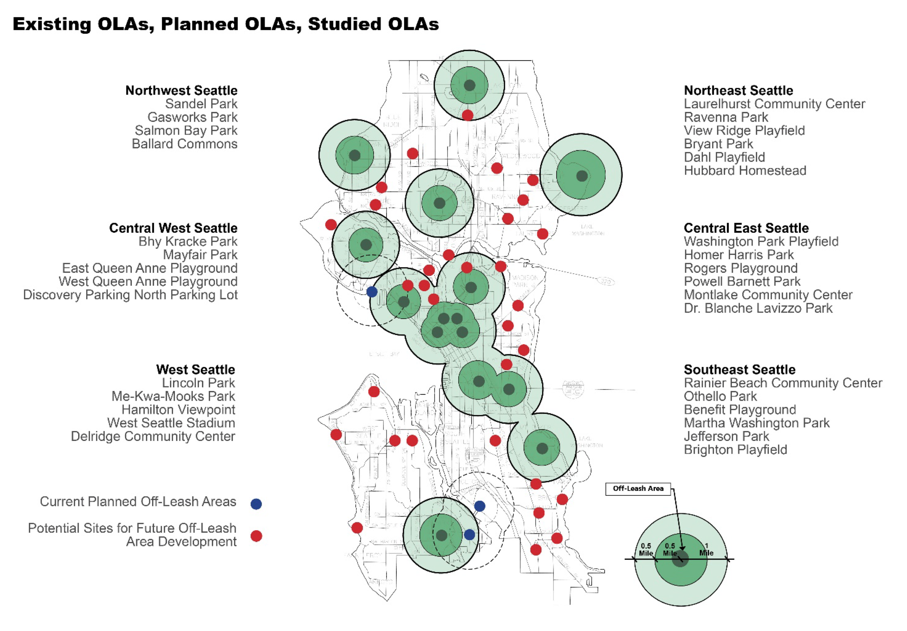
Green sites represent Off Leash Areas that are existing.
Blue sites represent Off Leash Areas that are in design. Red dots indicate sites that were included as part of this study.

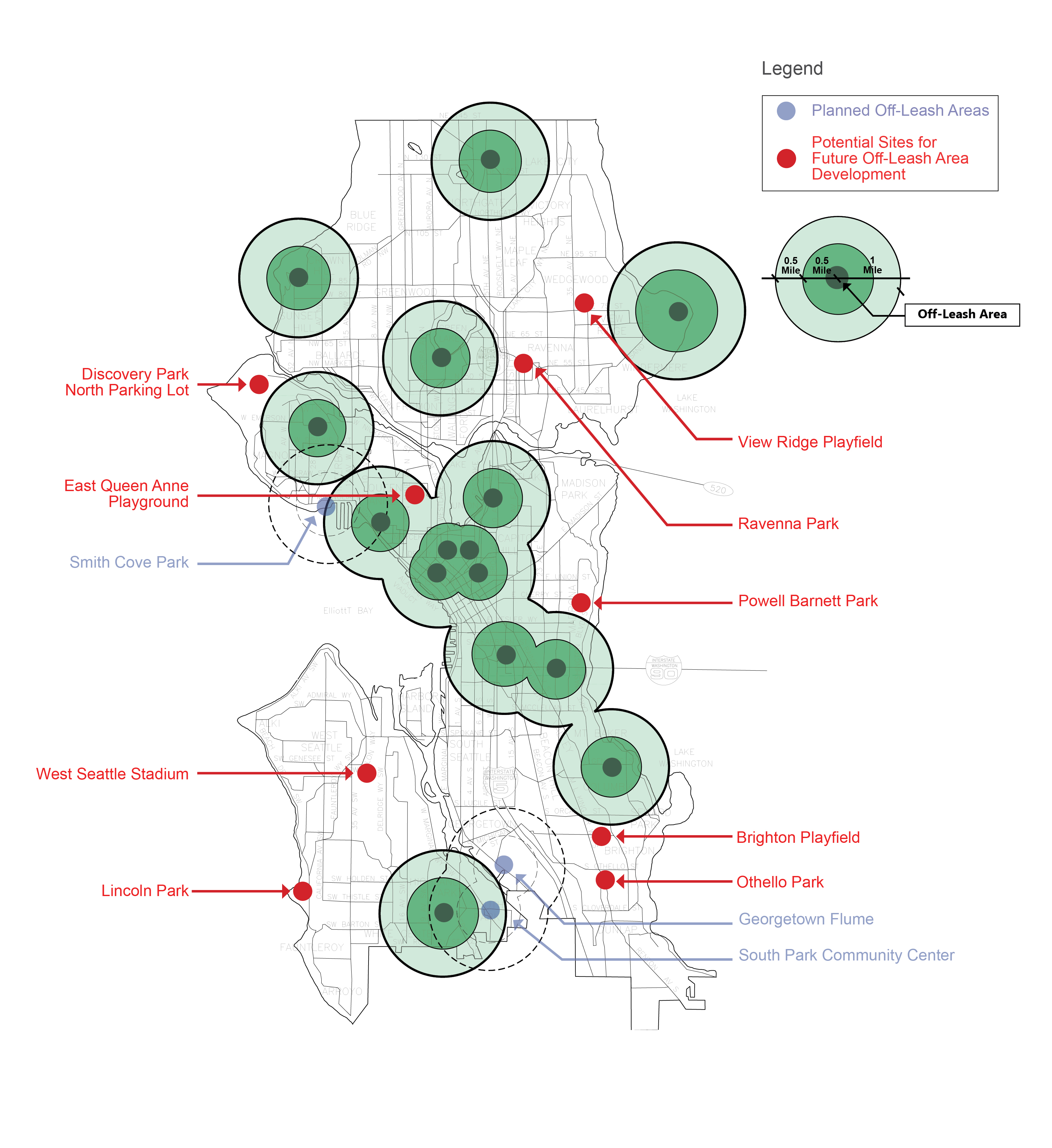
Existing OLAs, Planned OLAs, and Preferred OLA Sites
Green sites represent Off Leash Areas that are existing.
Blue sites represent Off Leash Areas that are in design. Red dots indicate sites that are recommended as part of this study and are up for consideration.
OLA Expansion Study: Recommended Sites Summary

Lincoln Park
Lincoln Park is a 127-acre regional park in the Fauntleroy neighborhood, in the southwest part of West Seattle. The study area at Lincoln Park is located in the central area of the park, directly west of the north playfield and separated by natural tree groves and a grounds maintenance area. The area is roughly 850 feet from the eastern parking area including accessible spaces and the path between the two currently uses a crushed rock surfacing. The surrounding area is primarily zoned single family residential and there is good pedestrian access with sidewalks and nearby crossings as well as regular transit access on Fauntleroy Way SW. The total study area is roughly 26,000 square feet and is relatively flat, covered in grass and bordered by trees on two sides. The site is connected into the park’s pathway network at the eastern and western ends and is buffered from all other uses by at least 50 feet of space and visual barriers. The study area does not include any ECAs though it does border with a Wildlife Habitat zone. The park does not contain any landmark or historical designations and while the location was recommended for a park in the 1908 Olmsted Brothers plan, they did not create a design for it. This study area meets the threshold criteria and should be considered for new OLA development. The nearest OLA is Westcrest Park which is a 3.5-mile drive from Lincoln Park.

West Seattle Stadium
West Seattle Stadium is a roughly 12-acre special use facility in the North Delridge neighborhood, but also adjacent to the Fairmount Park neighborhood. The study area at the West Seattle Stadium site is located just off West Seattle Stadium Road, just east of 35th Avenue SW. The area is relatively flat, surrounded by trees with steep slopes to the west and east. While some parts have long grasses, it is primarily covered in dirt as the area is used for overflow parking for the co-located stadium, golf course, and gun range but is otherwise closed with a chain and lock. The areas surrounding this section of the park vary with primarily commercial and high-density multi-family, along with some residential small lot. This entire bordering area is part of the West Seattle Junction Urban Village. 35th Avenue SW has regular RapidRide Metro service and dedicated pedestrian access to the site. The study area includes 16,000 square feet though a very small portion, less than 10% of this at the south end overlaps with a Wildlife Habitat ECA. The area is labeled as a GSP site according to SPR GIS data due to existing identified invasive plants. This area does not include any landmark or historical designations and the park is not part of any Olmsted Plan. Due to the intermittent use as overflow parking, use should be studied to determine if alternate parking arrangements can be made when needed. This site appears to meet the threshold criteria for OLAs and could be recommended for new OLA development in full or part. The nearest OLA is Westcrest Park which is a 4-mile drive from West Seattle Stadium.
East Queen Anne Playground
East Queen Anne Playground is a roughly 1.5-acre neighborhood park in Eastern Queen Anne near the center of the neighborhood. The study area at East Queen Anne Playground is the eastern half of the park and includes an area with a basketball hoop and half circle of pavement and a grass lawn playfield. The western half of the park is separated by an embankment with a retaining wall connected by a small staircase. Up the embankment is a playground, comfort station, wading pool, swing area. There is no dedicated parking for this park and transit access is available 2 blocks west of the park on Queen Anne Avenue. The park is surrounded by Neighborhood Residential zoning and the study area is bordered by trees with fencing that break the space from the surrounding streets. The study area is 28,400 square feet and does not include any ECAs or restoration areas. The park is not Olmsted inspired and includes no landmarks or historic designations. Current usage will need to be explored and parks scheduling consulted to determine regular users and whether the space can be fully or partially turned to a new use. This site does meet the threshold criteria for new OLA development and should be considered, however SPR scheduling, and neighborhood should be consulted to determine if a change in use is feasible and desired. The nearest OLA is Lower Kinnear Park which is a 1.5-mile drive from East Queen Anne Playground
Discovery Park
Discovery Park is located in central west Seattle at the end of the peninsula that the Magnolia neighborhood is on. The study area includes a large flat lawn space adjacent to the park’s northern parking lot near a comfort station and two rain gardens. The space is linear with a road and large tree covered natural areas to the north and south. The park and surrounding areas are zoned Neighborhood Residential, and it is not a part of any urban village. The site is directly adjacent to a large parking lot which also includes a bus stop for nearby transit access. The site has nearby wetland, steep slope, riparian corridor, and wildlife habitat ECAs, however the site only partially overlaps with the wildlife habitat ECA. With these ECAs removed the site still includes enough area to meet the minimum space required. GSP restoration zones also border the site but do not overlap and are at a variety of stages of restoration. The study area is approximately 25,000 square feet and does not include historic designations or landmarks. A landmarked structure is in the park a half mile away, however the controls on this designation are limited to the building itself and the space within 10 feet of the building exterior. The site of Discovery Park was noted in the 1910 Olmsted Plan and some plans for trails and drives to allow the public to access the fort that was already present. However this was not carried out and the park was not opened to the public fully until the base was decommissioned in 1973. This site appears to meet the threshold criteria for OLA development and should be considered if the existing site ECAs can be accommodated. The nearest OLA is Magnolia Manor Park which is a 1.9-mile drive from Discovery Park.
Ravenna Park
Ravenna Park is a community park in the northeastern sector of Seattle outside the north end of the University District Urban Center in the Ravenna neighborhood. The park is primarily natural space sloping down into a ravine with a creek running down the center of the property. The study area is a gently sloping lawn area near the southern end of the park bordered by lawn and natural areas. The park also features a wading pool, play area, tennis courts, comfort station and playfield nearby though not adjacent. The surrounding neighborhood is zoned Neighborhood Residential and does not include an Urban Village. There is a parking lot near to the study area and transit access is available to the streets surrounding the park. The study area is 20,000 square feet and is mostly free of any ECAs though there is a Wildlife Habitat zone in the northeast. The Wildlife Habitat zone can be excluded from the study area, and it will still meet the minimum area requirement for OLA consideration so this is not critical. The surrounding areas to the north in the park are part of a GSP restoration zone though this is not in the study area. The area has been noted by GSP to be the location of invasive plants that should be removed. This location was recommended for the development of a park as part of the 1903 Olmsted report and then again in 1908 though with different boundaries. The park was acquired by the city in 1909 and no Olmsted design was created or executed in the park. The 20th Avenue Northeast Bridge is a designated Seattle Landmark, however, the controls on this landmark area limited to the bridge itself and surrounding landscaping and should not place any limitations on this proposed area. The study area excluding the identified ECA appears to meet the threshold criteria for OLA development and should be considered. The nearest OLA is Lower Woodland Park which is a 2.5-mile drive from Ravenna Park.
View Ridge Playfield
View Ridge Playfield is a neighborhood park in northeast Seattle in the View Ridge neighborhood. The space is a flat lawn with a playfield to the north, and a half basketball hoop and comfort station to the south. The park also features a play area, picnic shelter, and wading pool. The park and surrounding neighborhood are zoned Neighborhood Residential and are not a part of any urban village. The park does not have dedicated parking, but transit access is available within a quarter mile of the park. The study area is approximately 17,000 square feet and does not include any ECAs or GSP restoration zones. View Ridge Playfield is not a part of any Olmsted Plan and does not contain any Landmarks or Historic designations. The space at View Ridge Playfield appears to meet the threshold criteria for OLA development and should be considered for OLA use. The nearest OLA is Magnuson Park which is a 1.3- mile drive from View Ridge Playfield.
Powell Barnett Park
Powell Barnett Park is in the Central Area and in the northwest corner of the Leschi neighborhood and just outside the 23rd & Union-Jackson Residential Urban Village. The study area covers a portion of flat lawn space at the north end of the park connected with the park’s existing path network and adjacent to a small informal picnic space. Most current formal uses of the park are centered around the south half which offers a variety of amenities including a play area, basketball court, adult fitness zone, comfort station, and wading pool. The surrounding neighborhood is primarily zoned Neighborhood Residential, with the Urban Village on the west side of Martin Luther King Jr Blvd zoned Residential Small Lot. The park does not have dedicated parking and there is transit access available at the park address. The study area is approximately 11,000 square feet and does not include any ECAs or GSP restoration zones. The park is not part of an Olmsted Plan and there are no landmarks or historic designations on the property. The neighboring picnic space would conflict with an OLA and would need to be relocated or removed. This site meets the threshold requirements for OLA development and should be considered if existing conflicting site conditions can be mitigated. The nearest OLA is Blue Dog Pond which is a 1.2-mile drive from Powell Barnett Park.
Othello Park
Othello Park is in southeast Seattle in the Brighton neighborhood in Rainier Valley. The study area is a gently sloped lawn space in the southwest corner of the park connected with trees and walking paths lining the street side. The park also features a play area, comfort station, basketball court, stage, and a hillside slide, mostly focused in the north and western portions of the park. The park and areas to the north and south are zoned Lowrise Multi-Family while the area to the west is Neighborhood Commercial and the area to the east is Residential Small Lot. The area is also a part of the Othello Residential Urban Village and while the park does not have dedicated parking there is transit access to the park including Link Light Rail access one block away. The study area does not include an ECAs, and the park has not identified restoration zones. The study area is approximately 12,000 square feet and does not include any Seattle Landmarks or historic designations and is not included in any Olmsted Plan. This study area appears to meet the threshold criteria adopted for OLA consideration and should be recommended for development. The nearest OLA is Genesee Park which is a 2.8-mile drive from Othello Park.
Brighton Playfield
Brighton Playfield is a community park located in the south end of the Columbia City neighborhood of Rainier Valley. The study area is a flat lawn space at the north end of the park and includes the existing location of a sand volleyball court. The north half of the park also features a swing set and play area along with a synthetic athletic field and comfort station. The park also features a tennis court and basketball courts at the south end. The park and surrounding neighborhood to the north and east are zoned Neighborhood Residential, but the west side of the park includes Neighborhood Commercial, High-Density Multi-Family and Residential Small Lot zoning. These three zones on the west side are all a part of the Othello Residential Urban Village which does not extend into the park. The park does not feature dedicated parking, but street parking is available and transit access is available nearby. The study area is approximately 22,000 square feet and does not feature any ECAs or restoration zones. The park does not include any Seattle Landmarks or historic designations and only the location, not any design, was included as a part of an Olmsted Plan for Seattle. This site at Brighton Playfield appears to meet all threshold criteria for OLA development and should be considered for selection. The nearest OLA is Genesee Park which is a 1.4-mile drive from Brighton Playfield.
_____________________________


